As a collaboration between the University of Illinois Chicago and Northern Illinois University and funded by the Illinois Innovation Network (IIN), the Sustainable Urban-Regional Modeling (SURe Modeling) Network Project focused on building a conceptual framework that would eventually inform formal simulation models. These efforts aimed to provide valuable insights for policymakers and researchers by highlighting the long-term implications of current social and economic policies, guiding more sustainable development strategies in the region.
The SURe Modeling Network Project is an interdisciplinary initiative aimed at addressing the complex interconnections between urban and rural areas, particularly in the context of energy, food, and water systems.
This project brings together a diverse group of stakeholders, including city planners, regional partners, and scholars from multiple institutions, to develop integrated models that reflect the social and ecological dynamics of the Northern Illinois region in the United States.

Generated by Dall-E.
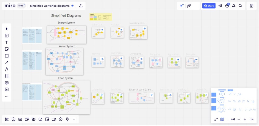
One of the core activities of the SURe Modeling project is the organization of collaborative workshops designed to engage local stakeholders in the creation of causal loop diagrams.
These causal loop diagrams serve as a tool to visualize and understand the complex feedback loops and interdependencies within urban-rural systems, particularly how policies and decisions in urban centers like Chicago impact surrounding areas. The workshops utilize platforms such as Miro for real-time collaboration. After the workshops, Gephi was used for the graph visualization and analysis, and Java for further implementation of simulation computational models, ensuring a holistic approach to modeling complex systems.
sub-models, and information about connection and levers. Source: Zellner et al. 2023
The project is grounded in the recognition that traditional research has often focused on large urban centers in isolation, neglecting the significant interactions between these cities and their surrounding regions. By incorporating perspectives from a broad array of regional stakeholders (with expertise in urban – rural interactions and the Food – Energy – Water domains) and using advanced computational tools, the SURe Modeling Network seeks to bridge this gap. The models developed will not only enhance our understanding of the interconnectedness of social and ecological systems but also provide actionable insights for policymakers, enabling them to anticipate the long-term consequences of their decisions.
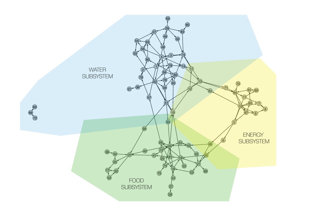
Each vertex represents a variable in the final causal-loop diagram, and each edge represents a directed connection between vertices.
Designed and created by Anton Rozhkov
As a collaboration of scholars from the University of Illinois Chicago, Northeastern University, and Northern Illinois University, the SURe Modeling project brought together a diverse group of experts in urban planning, environmental science, engineering, anthropology, sociology, economics, and urban governance. This interdisciplinary approach allowed for a comprehensive exploration of the complex factors influencing sustainable development in the Northern Illinois region. By integrating both qualitative and quantitative data, the project produced a rich body of research that not only advanced our understanding of urban sustainability but also provided practical insights for policymakers and community leaders. The lasting network established by the project continues to foster ongoing dialogue and collaboration, ensuring that the knowledge and expertise gained from the SURe Modeling project have a sustained impact on the development of sustainable pathways for not only Northern Illinois but also for other regions facing similar challenges.
The project was conducted by teams from the University of Illinois Chicago, Northeastern University, and Northern Illinois University in Spring 2021.
Tools used: [Miro] [Gephi] [Java]
Relevant publications:
- Zellner, M., D. Massey, A. Rozhkov, and J. T. Murphy. (2023). Exploring the Barriers to and Potential for Sustainable Transitions in Urban–Rural Systems through Participatory Causal Loop Diagramming of the Food–Energy–Water Nexus. Land, 12, no. 3: 551. https://doi.org/10.3390/land12030551
- Rozhkov, A., Zellner, M., Murphy, J. T., Massey, D. Identifying Leverage Points for Sustainable Transitions in Urban–Rural Systems: Application of Graph Theory to Participatory Causal Loop Diagramming. [Under Review]
